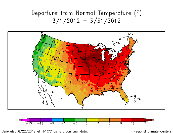
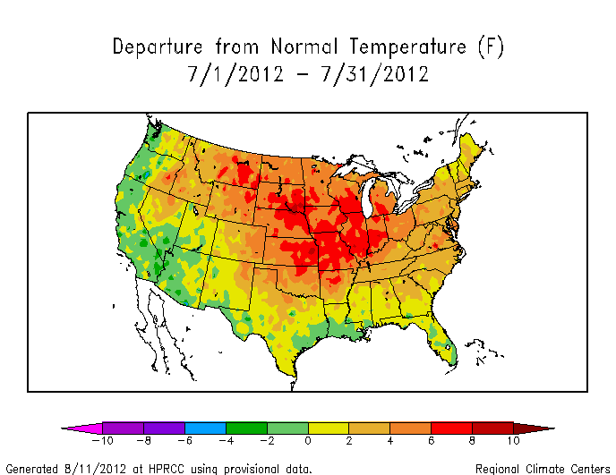
Glancing through the temperature anomalies of the last year, it’s clear we’re heading – barrelling really – towards a record hot year. Temperature data is collected and archived very quickly through various climate centers. The High Plains Regional Climate Center (HPRCC) has a particularly fluid interface for quickly assessing the state of the climate over different time and space (or spatiotemporal) scales. The USA as a whole experienced a record hot March and July in 2012, as listed in the table here. Records weren’t broken in every single state of course, but the records were broken when all the temperatures were averaged together. Here’s the story though. December 2012 is set to be the final nail in the plaque on the wall that says “HOTTEST YEAR ON RECORD: 1998 2012” and at this point (9 days into the month), December 2012 will not only be the nail, but will help 2012 shatter the temperature record. Look at these anomalies figures produced using the HPRCC tool for March, July, and so far for December:
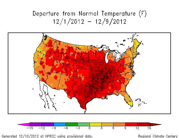
Without even reading a number, you know that the deep red color for the anomaly from December 1-9 implies that it’s much hotter than the average temperature for December 1-9**. There’s hardly a speck of any the green or yellow that represents near normal temperature! But let’s not overreact. Whether this early trend will continue depends on the weather. All things being equal, weather over the entire month will probably moderate the unusual warmth seen so far in December. However, human activities have fundamentally changed how the concept of “all things being equal” applies to weather, so better to look at what weather models are saying rather than just assuming… Near-term weather forecasts suggests that the first half of the month will be more of the same. Long-term weather forecasts for the month (for example, clicking on the options for 100 hr+ forecast times) suggest a nor’easter may develop around Dec 16 and subsequently affect the mid-Atlantic Dec 17-18, but even that weather system seems to bring rain rather than snow (use the same forecast tool and “precip type” option to see that). Regardless, there is no chance of widespread snowmen to cool things down before at least December 15. Odds are in favor of a shattered temperature record on New Years Day.
Shattering the temperature record?
Categories: Earth System Observer