A manuscript completed by Dr. Chen and his collaborators at North Carolina State University was recently accepted by ISPRS Journal of Photogrammetry and Remote Sensing, a high-profile remote sensing journal.
Title: Effects of LiDAR point density and landscape context on estimates of urban forest biomass
Abstract: Light Detection and Ranging (LiDAR) data is being increasingly used as an effective alternative to conventional optical remote sensing to accurately estimate aboveground forest biomass ranging from individual tree to stand levels. Recent advancements in LiDAR technology have resulted in higher point densities and improved data accuracies accompanied by challenges for procuring and processing voluminous LiDAR data for large-area assessments. Reducing point density lowers data acquisition costs and overcomes computational challenges for However, how does lower point density impact the accuracy of biomass estimation in forests containing a great level of anthropogenic disturbance? We evaluate the effects of LiDAR point density on the biomass estimation of remnant forests in the rapidly urbanizing region of Charlotte, North Carolina, USA. We used multiple linear regression to establish a statistical relationship between field-measured biomass and predictor variables (PVs) derived from LiDAR point cloud data with varying densities. We compared the estimation accuracies between a general Urban Forest type and three Forest Type models (evergreen, deciduous, and mixed) and quantified the degree to which landscape context influenced biomass estimation. The explained biomass variance of the Urban Forest model, using adjusted R2, was consistent across the reduced point densities, with the highest difference of 11.5% between the 100% and 1% point densities. The combined estimates of Forest Type biomass models outperformed the Urban Forest models at the representative point densities (100% and 40%). The Urban Forest biomass model with development density of 125 m radius produced the highest adjusted R2 (0.83 and 0.82 at 100% and 40% LiDAR point densities, respectively) and the lowest RMSE values, highlighting a distance impact of development on biomass estimation. Our evaluation suggests that reducing LiDAR point density is a viable solution to regional-scale forest assessment without compromising the accuracy of biomass estimates, and these estimates can be further improved using development density.
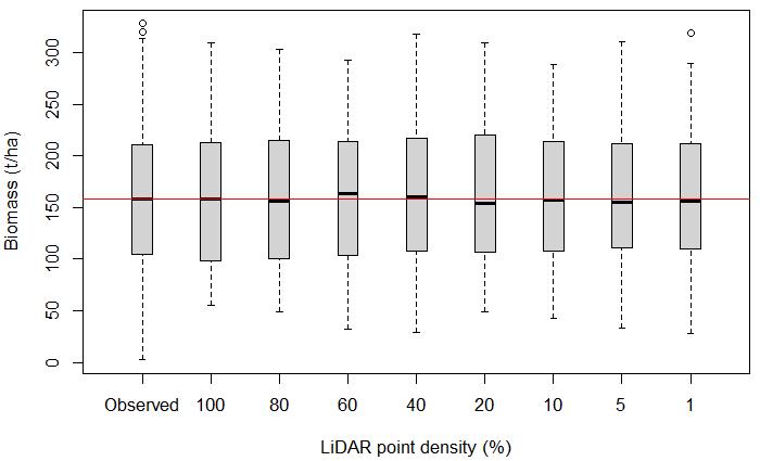
Predicted biomass categorized by LiDAR point density reduction with red horizontal line indicating the median of observed biomass.