He, Y., G. Chen, C. Potter, and R.K. Meentemeyer (in press). Integrating multi-sensor remote sensing and species distribution modeling to map the spread of emerging forest disease and tree mortality. Remote Sensing of Environment.
Abstract:
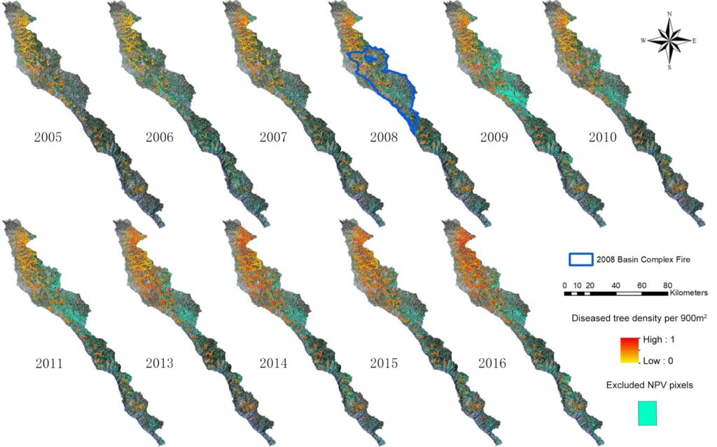
Forest ecosystems have been increasingly affected by a variety of disturbances, including emerging infectious diseases (EIDs), causing extensive tree mortality in the Western United States.Especially over the past decade, EID outbreaks occurred more frequently and severely in forest landscapes, which have killed large numbers of trees. While tree mortality is observable from remote sensing, its symptom may be associated with both disease and non-disease disturbances (e.g., wildfire and drought). Species distribution modeling is widely used to understand species spatial preferences for certain habitat conditions, which may constrain uncertain remote sensing approaches due to limited spatial and spectral resolution. In this study, we integrated multi-sensor remote sensing and species distribution modeling to map disease-caused tree mortality in a forested area of 80,000 ha from 2005 to 2016. We selected sudden oak death (caused by pathogen P. ramorum) as a case study of a rapidly spreading emerging infectious disease, which has killed millions of oak (Quercus spp.) and tanoak (Lithocarpus densiflorus) in California over the past decades. To balance the needs for fine-scale monitoring of disease distribution patterns and satisfactory coverage at broad scales, our method applied spectral unmixing to extract sub-pixel disease presence using yearly Landsat time series. The results were improved by employing the probability of disease infection generated from a species distribution model. We calibrated and validated the method with image samples from high-spatial resolution NAIP (National Agriculture Imagery Program), and hyperspectral AVIRIS (Airborne Visible/Infrared Imaging Spectrometer) sensors, Google Earth® imagery, and field observations. The findings reveal an annual sudden oak death infection rate of 7% from 2005 to 2016, with overall mapping accuracies ranging from 76% to 83%. The integration of multi-sensor remote sensing and species distribution modeling considerably reduced the overestimation of disease effects as compared to the use of remote sensing alone, leading to an average of 26% decrease in detecting disease-affected trees. Such integration strategy proved the effectiveness of mapping long-term, disease-caused tree mortality in forest landscapes that have experienced multiple disturbances.