Dr. Chen was invited to join the Editorial Advisory Board of the ISPRS Journal of Photogrammetry and Remote Sensing, which is the official journal of the largest international remote sensing society – International Society for Photogrammetry and Remote Sensing.
AUTHOR
Gang Chen
Dr. Chen joins the Editorial Advisory Board of the ISPRS Journal of Photogrammetry and Remote Sensing
Categories: Updates
Dr. Chen gave a talk at CAGIS
Categories: Updates
On Wednesday, Feb 24, Dr. Chen was invited by CAGIS (Center for Applied Geographic Information Science) at UNC Charlotte to give a talk, entitled “Remote sensing of forest disturbances”.
Paper accepted by J-STARS
Categories: Updates
A manuscript entitled “When Big Data are Too Much: Effects of LiDAR Returns and Point Density on Estimation of Forest Biomass”, and co-authored by Dr. Chen was recently accepted by the IEEE Journal of Selected Topics in Applied Earth Observations and Remote Sensing (J-STARS)!
Abstract:
Assessment of forest aboveground biomass and carbon stocks is increasingly dependent on Light Detection and Ranging (LiDAR) data. However, higher LiDAR point densities and return numbers pose challenges in procuring and processing voluminous LiDAR data for large-area assessments. Data reduction techniques are often used to overcome these challenges but rarely LiDAR returns are analyzed to estimate aboveground forest biomass. We examined the effects of LiDAR returns and data reduction on estimates of aboveground forest biomass in the Charlotte Metropolitan Region of North Carolina, USA. We extracted structural metrics using all returns, first returns, and first return of each laser pulse from reduced point densities (80%, 60%, 40%, 20%, 10%, 5%, and 1%) and the original LiDAR data. We used multiple linear regression to establish statistical relationships between field-measured biomass and LiDAR-derived predictor variables (PVs) for each return and point density combination. We selected non-collinear PVs using the Variance Inflation Factor, and identified the best set of explanatory PVs based on the lowest Akaike Information Criterion value. Using adjusted–R2, the explained variance of biomass models was consistent across all combinations of LiDAR returns and reduced point densities. While the greatest difference between 100% and 1% point densities was 13.3% for the first returns, all three return types performed consistently across all point densities. In addition, the variance of predicted biomass estimates was similar to field measured biomass across the spectrum of models. Our evaluation suggests that for regional-scale assessments of forest aboveground biomass, the use of first returns LiDAR data normalized by digital elevation model is an effective alternative to point density reduction that does not compromise the accuracy of biomass estimates.
Dr. Chen gave a talk at the University of South Carolina
Categories: Updates
On Friday, January 15, Dr. Chen was invited by the Department of Geography at the University of South Carolina to give a talk, entitled “Multisensor remote sensing for sustainable forest management”. The talk is also part of the Geography Colloquium at USC. Please see details here: http://artsandsciences.sc.edu/geog/geography-colloquium-dr-gang-chen.
Dr. Chen's Research Featured in Media - Mongabay
Categories: Updates
Dr. Chen’s research of the impact of building and operating the Tucuruí dam on deforestation in Amazon was featured in Mongabay, an environmental science and conservation news and information site. Here is the link to the report, titled “Forest loss increased annually for 25 years at oldest Amazon mega-dam”:
http://news.mongabay.com/2016/01/forest-loss-increased-annually-for-25-years-at-oldest-amazon-mega-dam/
Dr. Chen elected as Secretary/Treasurer of the ASPRS Potomac Region
Categories: Updates
Dr. Chen was recently elected as the Secretary/Treasurer of the ASPRS (American Society of Photogrammetry and Remote Sensing) Potomac Region. The Secretary/Treasurer serves for four years, progressing to Vice-President, President and Past-President.
See link for more details: http://asprspotomac.org/region-election-results-brown-region-director-chen-secretarytreasurer.
Dr. Ping Wang joins LRSEC
Categories: Updates
Dr. Ping Wang is visiting the LRSEC for a period of six months starting from December, 2015. Ping is currently a full professor at Shandong University of Science and Technology in China. Her main research interest is the application of remote sensing to monitor the change of our landscape, with an emphasis in the regions severely affected by mining.
Welcome aboard, Ping!
Ozelkan’s paper accepted by International Journal of Digital Earth
Categories: Updates
A recent submission by Drs. Emre Ozelkan and Gang Chen has been accepted by International Journal of Digital Earth. Congratulations, Emre!
Title: Spatial Estimation of Wind Speed: A New Integrative Model Using Inverse Distance Weighting and Power Law
Abstract:
Spatial interpolation (SI) is currently one of the most common ways to estimate wind speed (Ws). However, classic SI models either ignore the complex geography (e.g., inverse distance weighting (IDW)), or demand high computational resources (e.g., cokriging). This study aimed to develop a simple yet effective SI model for estimating Ws in Eastern Thrace of Turkey. This new method, named MIDW(Ws), is a modified IDW through the integration of IDW with wind profile model, power law (PL), representing the influence of land cover and topography on Ws. Terrain features and elevation data of PL were obtained using normalized difference vegetation index (NDVI) and digital elevation model (DEM), respectively. Results showed superior and comparable performance of MIDW(Ws) to standard IDW and ordinary kriging (OK) across all months of the tested year. Compared to ordinary cokriging (OCK) using DEM as covariate, MIDW(Ws) generated better results in the arid–semiarid seasons (around summer). Local complex atmospheric conditions during rainy seasons (around winter) may have affected the performance of incorporating PL with MIDW(Ws). Generally, the proposed MIDW(Ws) is simpler and easier to implement compared to OCK. For landscape–scale projects, its high computational efficiency and relatively robust performance show potential to deal with large volumes of data sets.
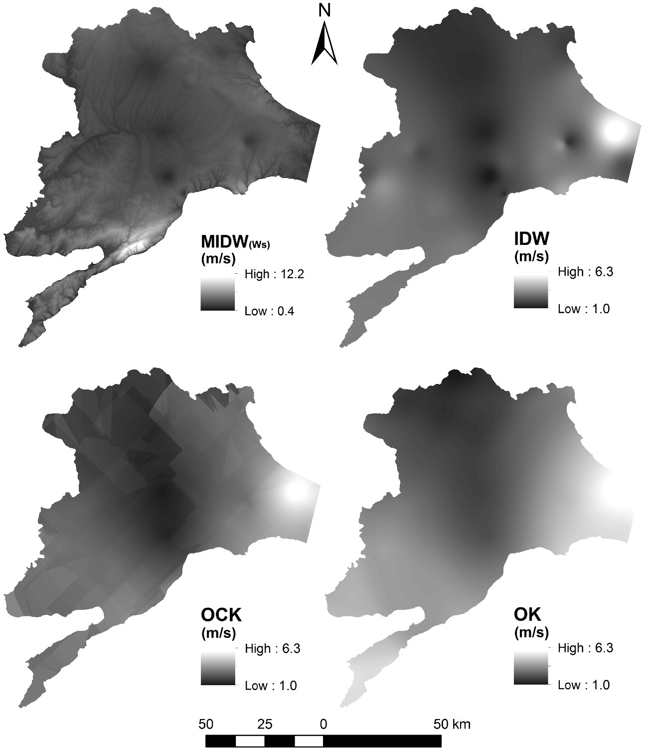
A comparison of wind speed spatial interpolation maps using MIDW(Ws), IDW, OCK, and OK.
Ozelkan's paper accepted by JAG
Categories: Updates
A recent submission by Drs. Emre Ozelkan and Gang Chen has been accepted by the International Journal of Applied Earth Observation and Geoinformation. Congratulations, Emre!
Title: Multiscale object-based drought monitoring and comparison in rainfed and irrigated agriculture from Landsat 8 OLI imagery
Abstract:
Drought is a rapidly rising environmental issue that can cause hardly repaired or unrepaired damages to the nature and socio-economy. This is especially true for a region that features arid/semi-arid climate, including the Turkey’s most important agricultural district – Southeast Anatolia. In this area, we examined the uncertainties of applying Landsat 8 Operational Land Imager (OLI) NDVI data to estimate meteorological drought – Standardized Precipitation Index (SPI) – measured from 31 in-situ agro-meteorological monitoring stations during spring and summer of 2013 and 2014. Our analysis was designed to address two important, yet under-examined questions: (i) how does the co-existence of rainfed and irrigated agriculture affect remote sensing drought monitoring in an arid/semi-arid region? (ii) What is the role of spatial scale in drought monitoring using a GEOBIA (geographic object-based image analysis) framework? Results show that spatial scale exerted a higher impact on drought monitoring especially in the drier year 2013, during which small scales were found to outperform large scales in general. In addition, consideration of irrigated and rainfed areas separately ensured a better performance in drought analysis. Compared to the positive correlations between SPI and NDVI over the rainfed areas, negative correlations were determined over the irrigated agricultural areas. Finally, the time lag effect was evident in the study, i.e., strong correlations between spring SPI and summer NDVI in both 2013 and 2014. This reflects the fact that spring watering is crucial for the growth and yield of the major crops (i.e., winter wheat, barley and lentil) cultivated in the region.
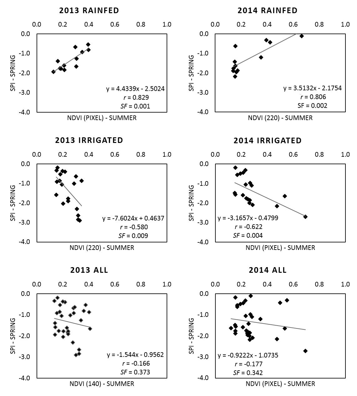
Sample correlations between spring SPI and summer NDVI of 2013 and 2014 for the rainfed, the irrigated and all the areas combined.
Jaime Lopez Joins the lab
Categories: Updates
Jaime will be visiting the LRSEC for one year starting from August, 2015. He is an assistant professor at the University of Tolima (Colombia), and is working towards his PhD degree at the National University of Colombia. For more details, please see his personal page on our website.
Welcome aboard, Jaime!