Dr. Chen was informed by Dr. Tim Warner, Editor in Chief of IJRS, that his 2012 “Object-based change detection” paper is the third-most cited paper published in the last 5 years in IJRS (and bear in mind that it has only had 3 years out of that 5 year period to gather citations).
Amazon dam-forest paper published in Applied Geography
Categories: Updates
To understand the “Spatiotemporal patterns of tropical deforestation and forest
degradation in response to the operation of the Tucuruí hydroelectric dam in the Amazon basin“, Dr. Chen and his collaborators from Yale University, Federal University of Lavras (Brazil), and Wageningen University and Research Centre (The Netherlands) published their results in the journal of Applied Geography.
Abstract:
The planned construction of hundreds of hydroelectric dams in the Amazon basin has the potential to provide invaluable ‘clean’ energy resources for aiding in securing future regional energy needs and continued economic growth. These mega-structures, however, directly and indirectly interfere with natural ecosystem dynamics, and can cause noticeable tree loss. To improve our understanding of how hydroelectric dams affect the surrounding spatiotemporal patterns of forest disturbances, this case study integrated remote sensing spectral mixture analysis, GIS proximity analysis and statistical hypothesis testing to extract and evaluate spatially-explicit patterns of deforestation (clearing of entire forest patch) and forest degradation (reduced tree density) in the 80,000 km2 neighborhoods of the Brazil’s Tucuruí Dam, the first large-scale hydroelectric project in the Amazon region, over a period of 25 years from 1988 to 2013. Results show that the average rates of deforestation were consistent during the first three time periods 1988-1995 (620 km2 per year), 1995-2001 (591 km2 per year), and 2001-2008 (660 km2 per year). However, such rate dramatically fell to half of historical levels after 2008, possibly reflecting the 2008 global economic crisis and enforcement of the Brazilian Law of Environmental Crimes. The rate of forest degradation was relatively stable from 1988 to 2013 and, on average, was 17.8% of the rate of deforestation. Deforestation and forest degradation were found to follow similar spatial patterns across the dam neighborhoods, upstream reaches or downstream reaches at the distances of 5 km to 80 km, suggesting that small and large-scale forest disturbances may have been influencing each other in the vicinity of the dam. We further found that the neighborhoods of the Tucuruí Dam and the upstream region experienced similar degrees of canopy loss. Such loss was mainly attributed to the fast expansion of the Tucuruí town, and the intensive logging activities alongside major roads in the upstream reservoir region. In contrast, a significantly lower level of forest disturbance was discovered in the downstream region.
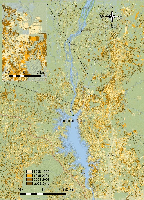
Fig 1. Deforestation map showing the spatial patterns of major tree loss over a 25-year period from 1988 to 2013.
Dr. Chen gives an invited talk at North Carolina Museum of Natural Sciences
Categories: Updates
On June 6, 2015, Dr. Gang Chen was invited by North Carolina Museum of Natural Sciences in Raleigh to give a talk titled “Counting Carbon in Trees from Space”. This is part of the LRSEC’s outreach activities, with an aim to help the general public, including K-12 students, understand how the cutting-edge remote sensing technologies can assist in more accurate forest carbon accounting in both urban and natural environments.
Link: http://naturalsciences.org/programs-events/science-saturday-counting-carbon-trees-space
Nandini Medampalle, sophomore at Phillip O. Berry High school, joins the LRSEC
Categories: Updates
Nandini Medampalle, a sophomore at Phillip O. Berry High school, will be working in the LRSEC for four weeks starting from mid-June. She will learn how to use remote sensing satellite imagery to map earthquake-induced infrastructure changes in Nepal. This is part of the LRSEC’s outreach activities with the aim to promote K-12 STEM education (with an emphasis on remote sensing digital image analysis) to underrepresented minority students.
Welcome Nandini!
William Sun admitted to the Geography MA program with teaching assistantship
Categories: Updates
William Sun was recently admitted to our Geography MA program to start in the Fall 2015 with a full teaching assistantship. Congratulations, Will!
Will received his bachelor’s degree from the Geography program at UNC Charlotte. As the newest member in the LRSEC, Will will work with Dr. Gang Chen to complete a project focused on urban forest management using high-resolution remote sensing.
Marilyn Brown selected as Charlotte Research Scholar
Categories: Updates
Marilyn Brown, an undergraduate student in Geography and Earth Sciences, was recently selected as a Charlotte Research Scholar (CRC) to be working at LRSEC. Congratulations, Marilyn!
Thanks to the CRC program, Marilyn is awarded $4000 to work with Dr. Chen during summer 2015 on an urban remote sensing project.
For more details about CRC, please refer to http://graduateschool.uncc.edu/current-students/charlotte-research-scholars.
Dr. Chen elected to the board of the AAG Landscape Specialty Group
Categories: Updates
Dr. Gang Chen was recently elected to the board of the AAG (Association of American Geographers) Landscape Specialty Group as Secretary-Treasurer. The two-year term starts right after the AAG’s Chicago conference in this April.
Research paper accepted by International Journal of Applied Earth Observation and Geoinformation
Categories: Updates
A recent paper entitled “Mapping burn severity in a disease-impacted forest landscape using Landsat and MASTER imagery” was accepted by the International Journal of Applied Earth Observation and Geoinformation. This project was led by Dr. Gang Chen, with collaborators from NC State, UC Davis and Lewis & Clark College.
Abstract
Global environmental change has increased forest vulnerability to the occurrence of interacting disturbances, including wildfires and invasive diseases. Mapping post-fire burn severity in a disease-affected forest often faces challenges because burned and infested trees may exhibit a high similarity in spectral reflectance. In this study, we combined (pre- and post-fire) Landsat imagery and (post-fire) high-spectral resolution airborne MASTER data [MODIS (Moderate Resolution Imaging Spectroradiometer) / ASTER (Advanced Spaceborne Thermal Emission and Reflection Radiometer)] to map burn severity in a California coastal forest environment, where a non-native forest disease sudden oak death (SOD) was causing substantial tree mortality. Results showed that the use of Landsat plus MASTER bundle performed better than using the individual sensors in most of the evaluated forest strata from ground to canopy layers (i.e., substrate, shrubs, intermediate-sized trees, dominant trees and average), with the best model performance achieved at the dominant tree layer. The mid to thermal infrared spectral bands (3.0–12.5 μm) from MASTER were found to augment Landsat’s visible to shortwave infrared bands in burn severity assessment. We also found that infested and uninfested forests similarly experienced moderate to high degrees of burns where CBI (Composite Burn Index) values were higher than 1. However, differences occurred in the regions with low burn severity (CBI values lower than 1), where uninfested stands revealed a much lower burn effect than that in infested stands, possibly due to their higher resilience to small fire disturbances as a result of higher leaf water content.
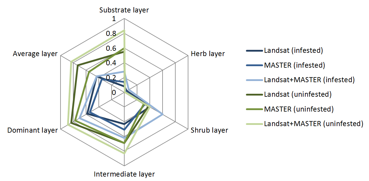
Comparison of coefficient of determination (R2) using Landsat, MASTER, and the Landsat and MASTER bundle for modeling burn severity in infested and uninfested forests.
New research paper accepted by IEEE Journal of Selected Topics in Applied Earth Observations and Remote Sensing
Categories: Updates
A manuscript entitled “Improving Pixel-Based Change Detection Accuracy Using an Object-Based Approach in Multitemporal SAR Flood Images” was accepted by IEEE Journal of Selected Topics in Applied Earth Observations and Remote Sensing.
This study proposes a new unsupervised algorithm-level fusion scheme to improve the accuracy of pixel-based change detection (PBCD) using spatial context information through: 1) getting the preliminary change mask with PBCD at first to estimate some parameters for object-based change detection (OBCD); 2) deriving the unchanged area mask to eliminate the areas without changes, reducing error amplification phenomenon of OBCD; and 3) obtaining the final change mask by means of OBCD method.
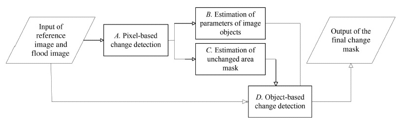
Proposed Workflow
Collaborative research paper accepted by Agricultural and Forest Meteorology
Categories: Updates
A manuscript entitled “Terrestrial lidar remote sensing of forests: Maximum likelihood estimates of canopy profile, LAI, and leaf angle distribution” was accepted by Agricultural and Forest Meteorology (IF=3.894).
This study aims to improve the utility of terrestrial lidar for vegetation survey by forging new TLS analyses to estimate foliage profile, leaf area index, and leaf angle distribution. We applied physical-based gap theories to build a maximum likelihood estimator (MLE) of vegetation structural parameters. Unlike classical gap-based algorithms, MLE explicitly accommodates laser scanning geometries, fully leverages raw information of laser ranging data, and simultaneously derives foliage profile and leaf angle distribution, with many additional theoretical advantages.
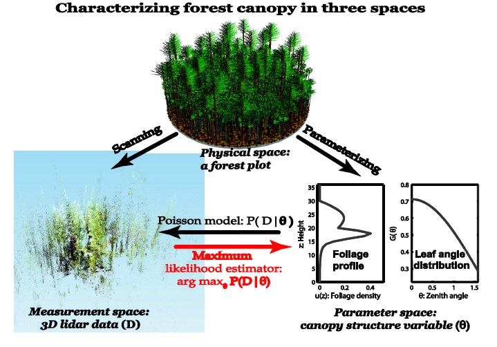
A forest canopy in three contrasting yet linked spaces: Physical, measurement, and parameter.