A great description of some of the unusual recent temperature swings in the north central part of the USA by Minnesota State Climatologist office with the original link here:
A taste of summer air surged into Minnesota on May 14th, sending the mercury soaring into the 80s and 90s across a good part of the state. A few locations even cracking 100 degrees. Notable exceptions were locations near ice covered lakes in northern Minnesota and near Lake Superior. At 2pm May 14th, the air temperature was 102 degrees at St. James and 44 degrees at Grand Marais. This kind of temperature range happens occasionally in the spring. One of the more dramatic episodes in recent years was May 19, 2009 when there was a difference of 66 degrees from Grand Marias to Granite Falls. The warmest temperatures found from a National Weather Service Cooperative site was 103 degrees from Sherburne 3 WSW in Martin County and Winnebago in Faribault County. Amboy also had reading of 102 degrees. Extremely dry air was in place as well, with desert-like relative humidity readings in the single digits at St. James. At 2pm while it was 102 degrees at St. James, the dew point temperature was only 28 degrees, creating a relative humidity of seven percent. Very low relative humidity readings happen on occasion. On April 28, 2004 the relative humidity dipped to just 2% at Pipestone. The lowest relative humidity reading ever recorded in the Twin Cities is 10% measured at 5pm April 22, 1953. The statewide hottest maximum temperature for the entire month of May is 112 degrees measured at Maple Plain in Hennepin County on May 31,1934. The Twin Cities had a high temperature of 98 degrees on May 14. This broke the old record high of 95 degrees that was set in 1932. This is also the hottest temperature recorded so early in the season for the Twin Cities. Ironically, despite how cool it has been this spring, 2013 had its first 90 plus degree day in the Twin Cities four days earlier than 2012, which hit 93 on May 18.
That last line is a pretty interesting weather tidbit, noting that the salient graphs from NCDC are below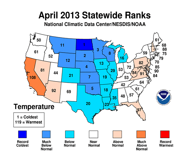
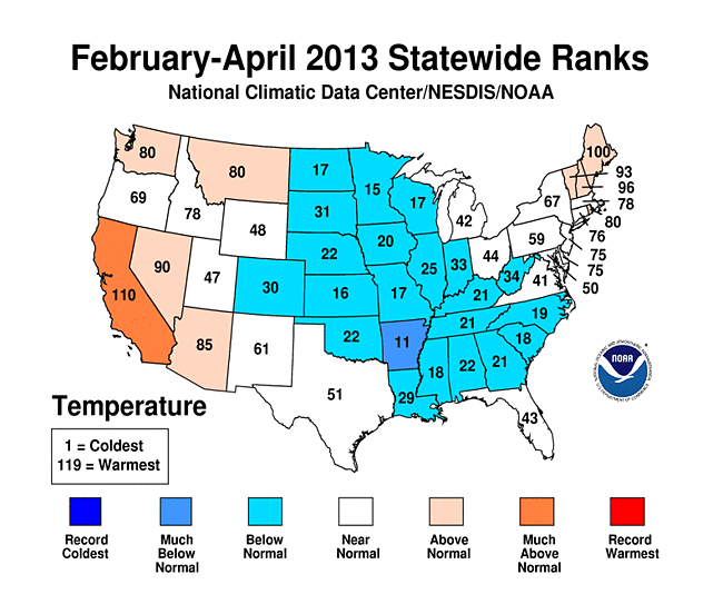 North Dakota had its coldest April in 119 years! Yow. Most of the central part of the country was colder than average, but by comparing the April 2013 to the multimonth average February-April 2013 plot, you can see signs of the transition out of spring to summer as well as parts of the country which had an above-average warm month (California, mid-Atlantic, Nevada, Arizona). More about this later – but these “extremes” are exactly the kind of weather we can expect as the Arctic warms or stays warmer than usual due to less sea ice.
  The Sun will eventually win this battle and the mid-latitudes (southern USA) will inevitably heat up this year (at least I think so!). Here’s the temperature departure for the last week from HPRCC which clearly shows relatively warm temperatures creeping from the Pacific Northwest into the heretofore frozen Great Plains.
 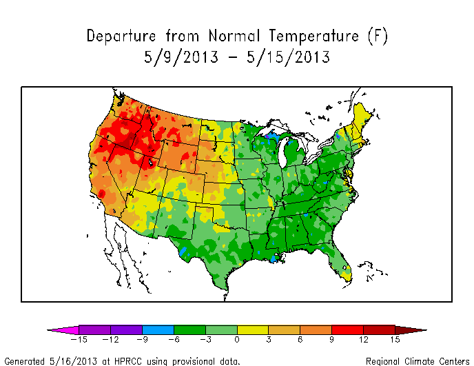 Summer is coming. Will Summer 2013 be like Summer 2012? Another question for another day.