We are happy to welcome Jonathan Finnin to the LRSEC as a new M.A. in Geography student! Jonathan joins us from James Madison University with a strong background in GIS and sustainability, including valuable experience as an ORISE intern at the USDA Agricultural Research Service where he utilized unmanned systems for water quality assessments. An avid outdoorsman with a passion for physical geography, Jonathan is a fantastic addition to our research team. Welcome aboard!
AUTHOR
Gang Chen
Welcome to the Lab, Jonathan!
Categories: Updates
New Faces in the Lab: Alden, Carter, and Sam
Categories: Updates
We are excited to welcome three new MA students to our research lab this semester! 🎉
- Carter Mayhew
- James (Sam) Penry
- Alden Sanderson
We look forward to the energy, ideas, and perspectives they will bring to our projects. Welcome to the team!
Welcome Austin Barbee to join LRSEC
Categories: Updates
Austin Barbee has a strong interest in remote sensing, land change and forest regeneration. He received a Bachelor’s Degree in Crime Analytics from UNC Charlotte. At the LRSEC, he will pursue his MA degree in remote sensing and environmental sustainability.
Welcome abroad, Austin!
Welcome Justin Erlick to join the lab
Categories: Updates
Justin Erlick came to the lab with a strong remote sensing and GIS background. He received his master’s degree from NC State and the B.S. from Arizona State University. At the LRSEC, he will pursue his PhD degree focusing on remote sensing and environmental disasters and hazards.
Welcome abroad, Justin!
Welcome Rachel to join the lab
Categories: Updates
Rachel Caron recently joined the lab. Her strong background in environmental management, coupled with the BS in Natural Resources from NC State, makes a valuable addition to our lab.
Welcome aboard, Rachel!
Welcome Ravi to join the lab
Categories: Updates
As a new PhD student, Ravi Thapaliya joined the lab this fall with a strong background in remote sensing and environmental modeling. Ravi received his master’s degree from Clark University and his bachelor’s degree from The Institute of Forestry, Pokhara in Nepal.
Welcome aboard, Ravi!
Congrats Evan on successfully defending his master's thesis
Categories: Updates
Evan Blomquist successfully defended his MS thesis entitled: “Urban form and air quality: a fine-scale look at 22 major U.S. cities”. Congrats, Evan!
Evan has decided to join an environmental consulting company in Atlanta. All the best in your future endeavors, Evan!
New article published in Environmental Research Letters (ERL)
Categories: Updates
A new article led by Sam Nickerson, a former MA student of the lab has been published in an open-access journal ERL with a high impact factor 6.947.
Nickerson, S., Chen, G., Fearnside, P.M., Allan, C.J., Hu, T., de Carvalho, L.M.T., & Zhao, K. (2022). Forest loss is significantly higher near clustered small dams than single large dams per megawatt of hydroelectricity installed in the Brazilian Amazon. Environmental Research Letters, 17, 084026.
Abstract
Hydropower in the Brazilian Amazon is a prevalent form of development, but dams have widespread and long-term environmental impacts that include deforestation in the areas surrounding the dams. Small hydropower plants (SHPs) are often perceived as having reduced environmental impacts compared to the large ones. In Brazil, SHPs are licensed by state governments, which have less strict requirements than the federal environmental agency. Brazil’s definition of ‘small’ dams has grown with successive increases in the maximum installed capacity from 10 to 30 to 50 megawatts (MW). This expanding loophole has increased the attractiveness of investing in multiple small dams rather than a single large dam, with resulting proliferation of SHPs. Forest dynamics surrounding the clustered SHPs when compared to single large dams are not well documented. In this study, we capitalized on a dense time series of satellite images to quantify and compare forest loss in the regions (over 110 000 km2 in area) surrounding 15 SHPs and 7 large dams at multiple watershed and buffer scales in the Brazilian Amazon for nearly two decades (2000–2018). The landscapes containing SHP clusters had lower cumulative forest loss as compared to those with large dams. However, when deforestation and hydroelectric generating capacity were jointly considered (i.e. forest loss per megawatt installed), we discovered an opposite trend. The regions surrounding the SHP clusters exhibited significant impacts ranging from 1.9 to 2.5 times that of the regions surrounding large dams across 5 km to sub-basin scales. Due to the considerable consequences of SHPs on deforestation, we argue that the rapid expansion of small hydropower should be approached with caution and requires more stringent environmental assessments.
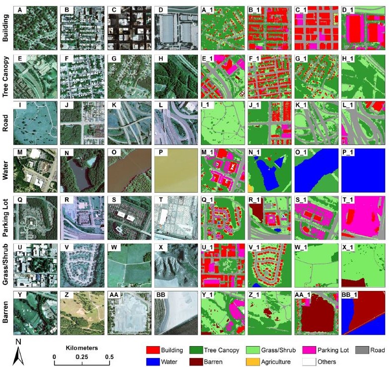
UrbanWatch: 1-meter resolution urban land cover and land use maps for major U.S. cities
Categories: Updates
Main characteristics of UrbanWatch:
▪ Very high spatial resolution at 1 meter.
▪ Open access (free): https://urbanwatch.charlotte.edu/product.
▪ 9 land cover/use types: building, road, parking lot, tree canopy, grass/shrub, water, agriculture, barren, and others.
▪ Overall accuracy of 91.52%.
▪ Coverage of 23 major U.S. cities (more to add).
▪ Peer reviewed and published in the journal Remote Sensing of Environment (ranked #1 in remote sensing, impact factor: 10.164).
▪ Cutting-edge AI deep learning algorithm, trained with over 52 million samples to capture diverse land cover and land use types and urban spatial patterns.
▪ Below please find some examples of various types of land cover and land use (e.g., “A”, “B”, and “AA”) and their corresponding results in UrbanWatch (e.g., “A_1”, “B_1”, and “AA_1”).
A study on fine-scale human disturbance detection appears in the ISPRS Journal
Categories: Updates
Hu, T., Toman, E. M., Chen, G., Shao, G., Zhou, Y., Li, Y., Zhao, K., & Feng, Y. (2021). Mapping fine-scale human disturbances in a working landscape with Landsat time series on Google Earth Engine. ISPRS Journal of Photogrammetry and Remote Sensing, 176: 250-261.
Abstract:
Large fractions of human-altered lands are working landscapes where people and nature interact to balance social, economic, and ecological needs. Achieving these sustainability goals requires tracking human footprints and landscape disturbance at fine scales over time—an effort facilitated by remote sensing but still under development. Here, we report a satellite time-series analysis approach to detecting fine-scale human disturbances in an Ohio watershed dominated by forests and pastures but with diverse small-scale industrial activities such as hydraulic fracturing (HF) and surface mining. We leveraged Google Earth Engine to stack decades of Landsat images and explored the effectiveness of a fuzzy change detection algorithm called the Bayesian Estimator of Abrupt change, Seasonality, and Trend (BEAST) to capture fine-scale disturbances. BEAST is an ensemble method, capable of estimating changepoints probabilistically and identifying sub-pixel disturbances. We found the algorithm can successfully capture the patterns and timings of small-scale disturbances, such as grazing, agriculture management, coal mining, HF, and right-of-ways for gas and power lines, many of which were not captured in the annual land cover maps from Cropland Data Layers—one of the most widely used classificationbased land dynamics products in the US. For example, BEAST could detect the initial HF wellpad construction within 60 days of the registered drilling dates on 88.2% of the sites. The wellpad footprints were small, disturbing only 0.24% of the watershed in area, which was dwarfed by other activities (e.g., right-of-ways of utility transmission lines). Together, these known activities have disturbed 9.7% of the watershed from the year 2000 to 2017 with evergeen forests being the most affected land cover. This study provides empirical evidence on the effectiveness and reliability of BEAST for changepoint detection as well as its capability to detect disturbances from satellite images at sub-pixel levels and also documents the value of Google Earth Engine and satellite timeseries imaging for monitoring human activities in complex working landscapes.