The Laboratory for Remote Sensing and Environmental Change (LRSEC)
An Interdisciplinary Research Group Using Remote Sensing and Geospatial Science to Understand Landscape Change
  • Home
  • Publications
  • Research Products
  • Team
    • Dr. Gang Chen
    • Chenyu Xing
    • Ravi Thapaliya
    • Rachel Caron
    • Justin Erlick
    • Austin Barbee
  • Prospective Students
  • Teaching
  • News

Latest News in LRSEC

  • Welcome Austin Barbee to join LRSEC October 3, 2024
  • Welcome Justin Erlick to join the lab September 16, 2024
  • Welcome Rachel to join the lab March 21, 2024

Contact Lab Director

Dr. Gang Chen
Address: McEniry 446, 9201 University City Blvd, Charlotte, NC 28223, USA (35°18'26"N 80°43'48"W)
Email: Gang.Chen 'at' charlotte.edu

Links

  • Department of Earth, Environmental and Geographical Sciences
  • College of Humanities & Earth and Social Sciences
  • University of North Carolina at Charlotte
Assistant Professor, Department of Geography and Earth Sciences
AUTHOR

Gang Chen

New book chapter published in Remote Sensing for Sustainability

December 01, 2016 by Gang Chen
Categories: Updates

A new chapter entitled “Remote Sensing of Forest Damage by Diseases and Insects” was recently published in the book “Remote Sensing for Sustainability” (by CRC Press).

Chen, G., and R.K. Meentemeyer (2016). Remote Sensing of Forest Damage by Diseases and Insects. In Q. Weng (Ed.), Remote Sensing for Sustainability (pp. 145-162). Boca Raton, Florida: CRC Press, Taylor & Francis Group.

The chapter is a review communication, which (i) summarizes the recent trends of remotely detecting forest disease and insect outbreaks, (ii) investigates the qualifications of remote sensing for studying the topic, (iii) provides a brief review of remote sensing algorithms, and (iv) discusses several remaining challenges.

For more details about the chapter, please refer to: https://www.crcpress.com/Remote-Sensing-for-Sustainability/Weng/p/book/9781498700719.

Research paper accepted by Journal of Environmental Management

November 25, 2016 by Gang Chen
Categories: Updates

New research paper was accepted by the Journal of Environmental Management.

Title: Uncertainties in mapping forest carbon in urban ecosystems

Abstract:

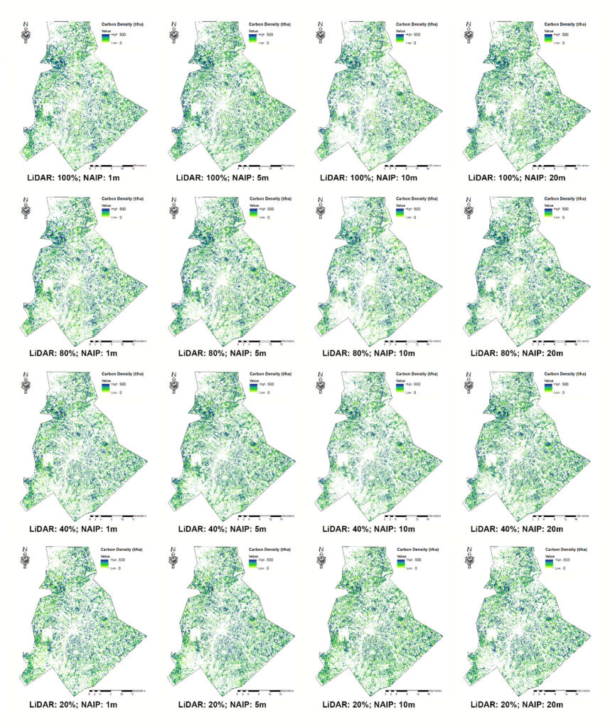
Spatially explicit urban forest carbon estimation provides a baseline map for understanding the variation in forest vertical structure, informing sustainable forest management and urban planning. While high-resolution remote sensing has proven promising for carbon mapping in highly fragmented urban landscapes, data cost and availability are the major obstacle prohibiting accurate, consistent, and repeated measurement of forest carbon pools in cities. This study aims to evaluate the uncertainties of forest carbon estimation in response to the combined impacts of remote sensing data resolution and neighborhood spatial patterns in Charlotte, North Carolina. The remote sensing data for carbon mapping were resampled to a range of resolutions, i.e., LiDAR point cloud density – 5.8, 4.6, 2.3, and 1.2 pts/m2, aerial optical NAIP (National Agricultural Imagery Program) imagery – 1, 5, 10, and 20 m. Urban spatial patterns were extracted to represent area, shape complexity, dispersion/interspersion, diversity, and connectivity of landscape patches across the residential neighborhoods with built-up densities from low, medium-low, medium-high, to high. Through statistical analyses, we found that changing remote sensing data resolution introduced noticeable uncertainties (variation) in forest carbon estimation at the neighborhood level. Higher uncertainties were caused by the change of LiDAR point density (causing 8.7-11.0% of variation) than changing NAIP image resolution (causing 6.2-8.6% of variation). For both LiDAR and NAIP, urban neighborhoods with a higher degree of anthropogenic disturbance unveiled a higher level of uncertainty in carbon mapping. However, LiDAR-based results were more likely to be affected by landscape patch connectivity, and the NAIP-based estimation was found to be significantly influenced by the complexity of patch shape.

carbon-maps

Fig 1. Forest carbon maps derived from four resolutions (1, 5, 10 and 20 m) of NAIP images, four densities of LiDAR point clouds (100%, 80%, 40% and 20% of the original data).


Two new graduate students, Caroline and Juan, join the LRSEC

August 10, 2016 by Gang Chen
Categories: Updates

Two new students, Caroline Narron and Juan Geng will take a new journey at LRSEC starting in the Fall, 2016!

Caroline will pursue her PhD degree, while Juan will work towards her MA degree. Both of their projects will focus on analyzing the response forest ecosystems to natural and anthropocentric disturbances using geospatial technologies.

Welcome aboard, Caroline and Juan!

New paper accepted by the journal Urban Ecosystems

August 03, 2016 by Gang Chen
Categories: Updates

A recent submission, entitled “Assessing effect of dominant land-cover types and pattern on urban forest biomass estimated using LiDAR metrics” was accepted to be published in the journal Urban Ecosystems.

The study examines the relationship between biomass and land cover from three
perspectives. First, we examine the local effects of dominant land cover types on urban forest biomass. Second, identify the spatial scale at which dominant land cover influences biomass estimates. Finally, investigate whether the fine-scale spatial heterogeneity of the urban landscape contributes to forest biomass.

Dr. Chen gave a workshop at the PRSCO 2016 meeting in Thailand

June 29, 2016 by Gang Chen
Categories: Updates

Dr. Chen was invited to give a workshop at the 14th Pacific Regional Science Conference Organization (PRSCO) Summer Institute on June 27th in Bangkok, Thailand. The workshop, entitled “Satellite and Airborne Remote Sensing to Support Social Science Research”, aimed to offer a basic instruction in the use and interpretation of remote sensing systems, data, and products, to benefit social scientists in their research.

Here is the link to the workshop: http://www.prsco2016.com/Workshop.html.

Matthew Guilin joins the LRSEC as Charlotte Research Scholar

May 31, 2016 by Gang Chen
Categories: Updates

Matthew Guilin, an undergraduate student in the Department, will conduct his summer research in the LRSEC. As a Charlotte Research Scholar, he will apply remote sensing image time series to detect deforestation in the Amazon Basin.

Welcome aboard, Matthew!

Yinan won the Student Presentation First Place Award at the AAG meeting

May 09, 2016 by Gang Chen
Categories: Updates

Yinan He, our second-year PhD student, won the Student Presentation First Place Award sponsored by the AAG Landscape Specialty Group.

Excellent work, Yinan!

Yinan He presented at AAG

April 04, 2016 by Gang Chen
Categories: Updates

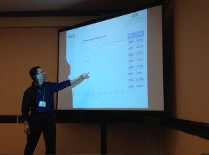
Yinan He, a LRSEC’s second year PhD student, presented his most recent research entitled “Integrating spectral, spatial and temporal information to map long-term forest disease progression”, at the annual AAG meeting in San Francisco.

Well done, Yinan!

HE_AAG_2016

Dr. Chen receives Early Career Scholar in Remote Sensing Award from AAG

March 02, 2016 by Gang Chen
Categories: Updates

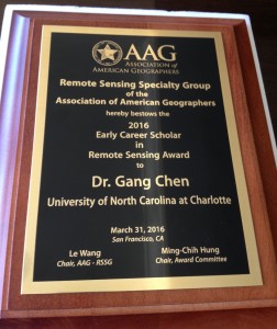
Dr. Chen received the Early Career Scholar in Remote Sensing Award, sponsored by the Remote Sensing Specialty Group (RSSG) of the Association of American Geographers (AAG). The Award “seeks to recognize exemplary research scholarship in remote sensing by individuals with a doctorate degree in Geography or allied fields”.

AAG_EarlyCareer

Dr. Chen joins the Editorial Advisory Board of the ISPRS Journal of Photogrammetry and Remote Sensing

February 27, 2016 by Gang Chen
Categories: Updates

Dr. Chen was invited to join the Editorial Advisory Board of the ISPRS Journal of Photogrammetry and Remote Sensing, which is the official journal of the largest international remote sensing society – International Society for Photogrammetry and Remote Sensing.

« Older Posts
Newer Posts »
Copyright © 2012-2025 Gang Chen, University of North Carolina at Charlotte. All rights reserved.
Skip to toolbar
  • Log In