Long-term changes in water scarcity
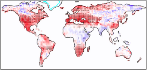
Climate models robustly project that terrestrial “drought” and “aridity”, as measured by common metrics like the Palmer Drought Severity Index, Aridity Index, and Standardized Precipitation-Evapotranspiration Index, are expected to greatly increase in coverage and severity in a warming world. This occurs because warming temperatures increase the rate at which exposed water evaporates (i.e. the potential evaporation) but do not systematically increase the precipitation supplied to the surface.
Yet, these very same climate models also project that river & groundwater runoff generation will not systematically decline, that root-zone soil moisture will not systematically dry, and that vegetation will green up globally rather than dying off. For both rivers and vegetation, these projections are well-confirmed by observations – both for the historical anthropogenic warming, and for the warming from the last Pleistocene Ice Age into the pre-industrial Holocene. Thus, the “drought” and “aridity” index-based projections do not seem to be relevant for key real-world impacts of climate change so far, even though the indices are familiar tools of hydrologists, ecologists and agriculturists.
 So, why don’t the indices match the impacts? Some early studies implicated direct CO2 effects on leaf physiology. However, I and others have found that the index-based drought projections are still very different from direct impact projections even in model experiments in which leaves cannot “see” the CO2 concentration. Using detailed land-model simulations, we then found that the increased “flashiness” of precipitation with global warming is equally or more important for explaining the index-impact gap, particularly when it comes to river runoff. The effect of widening vapor-pressure deficits on leaf physiology, and the increased seasonality of precipitation with climate change, also play key supporting roles.
Given all of this, then, how is global warming affecting runoff, soil moisture and vegetation in the real world? Where are the drying temperature effects predominating, vs. where are the wettening leaf-physiological and/or precipitation-timing effects predominating? Over the next several years, my PhD student Grace Mazaleski will be carrying out a systematic comparison of the available long-term runoff, soil moisture, and vegetation trends to known long-term precipitation trends to empirically answer this question. With Sloan Coats (U. Hawaii) and Flavio Lehner (Cornell), I am also planning to construct targeted modeling experiments to test the reasons for any discrepancies. This work will lead to a deeper understanding of how climate change affects terrestrial water abundance, with key implications for resource managers and other stakeholders.
Polar vs. tropical “tug of war” on the atmospheric circulation
 In the extratropics, models tend to indicate that jets, storm tracks, and rain belts will strengthen and shift poleward as the world warms. Fundamentally, this is because in the middle and upper troposphere the models tend to warm the tropics much more than the high latitudes, strengthening the planetary temperature gradient that drives the circulation. The opposite warming pattern occurs in the lower troposphere, where it is termed polar amplification, but the upper-level strengthening “wins out” dynamically in most models.
However, key observational products, such as the satellite-based Microwave Sounding Unit record and several state-of-the-art global reanalyses, indicate that polar amplification has in fact been occurring through the whole depth of the troposphere since 1979 in the northern hemisphere — not just in the lower troposphere. This would suggest that the northern extratropical circulation should in fact be slowing and shifting equatorward, rather than strengthening and shifting poleward.
 My recent MS graduates Maya Robinson and Nick Golden more carefully quantified and tested this discrepancy, and attempted to understand its origins. In particular, Maya found that modern (CMIP6) climate models reproduce the deep polar amplification and jet slowdown since 1979 much better than previous generations of models – yet still “reverse” to tropical amplification and jet speed-up in the future! Future work will attempt to uncover the root of this nonlinearity using additional CMIP6 analyses, as well as simple forcing-feedback theories.
Climate change, moist extremes, and impacts
 Much of the published work on heat waves under climate change naturally focuses on temperature. However, recent studies have highlighted that the key parameter for heat impacts on human health and functioning is actually wet-bulb temperature, which in warm climates depends much more strongly on dewpoint than on temperature. Because the conditions that lead to extremely high short-term temperatures usually also cause low dewpoints, it is not clear whether dewpoint extremes have the same causes, distributions, or trends as temperature extremes. My recent MS graduate Cody Burroughs brought new clarity to this question by quantifying 1948-2020 trends in both median and extreme percentiles of summertime dewpoint at hundreds of stations across the U.S. Unexpectedly, he found major spatial variation, including large regions of weak, insignificant dewpoint trends (or even significant declines) alongside large regions with very strong upward trends. Future work will attempt to understand the driver(s) of these patterns.
 Climate change is also prominently causing short-term very heavy rain events to increase in severity and frequency, as the atmosphere moistens. Here in North Carolina, such events led to catastrophic river flooding during Hurricanes Matthew (2016) and Florence (2018) that displaced thousands, disproportionately affecting majority-minority communities located in floodplains in southern and eastern NC. Motivated by these disasters, my MS student Zed Bates-Norris combined CORDEX regional precipitation projection ensembles with historical source research, as well as floodplain and Census data, to explain the societal and physical reasons for the disproportionate impact to minorities of future flooding increases in NC.
Tropical precipitation, circulation and climate change
State-of-the-art climate model projections for how global warming will affect regional precipitation in the tropics are literally all over the map: at each individual location, some models project a wetter future (with more rising motion) while others project a dryer future (with more sinking motion.) Because the models are so complex, we don’t know which ones are right, frustrating society’s efforts at climate adaptation and planning.
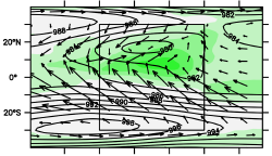
In an attempt to reduce this uncertainty, Michela Biasutti, Aiko Voigt and I organized the Tropical Rainbelts with an Annual-cycle and a Continent Model Intercomparison Project or TRACMIP, in which 15 different models each simulated the warming of an extremely simple world consisting of a flat rectangular tropical “continent” surrounded by a globe-spanning, unmoving ocean. Even in this highly idealized setup, however, the precipitation and circulation responses are still extremely diverse from model to model. In particular, the classic “energetic theory” that zonal-mean ITCZ shifts are controlled by changes in inter-hemispheric heat transport, does not even seem to hold in TRACMIP.
 To understand this result, my recent PhD graduate Xiaoyu Bai developed a new diagnostic framework that examined spatial shifts in each link of the chain connecting energy transport to the ITCZ. She found in particular that shifts in total energy transport were not necessarily related to shifts in Hadley-cell energy transport, undermining a key assumption of the energetic theory and suggesting a role for non-zonal processes such as monsoons and waves in the zonal-mean ITCZ response. (This project was funded by NSF AGS/CLD award “The essential dynamics of tropical rain belts: monsoons and ITCZ in a multi-model ensemble of idealized simulations” to Biasutti, Voigt and Scheff in 2016.)
Water in paleoclimates
 Changes in terrestrial water availability have also been prominent throughout human prehistory, as I documented for the last Ice Age several years ago. With Pat Fall, Steven Falconer, Missy Eppes and others, I have obtained an NSF Archaeology grant to create high-resolution (~1km) Holocene-scale temporal reconstructions of Mediterranean precipitation and temperature, enabling detailed vegetation and settlement modeling that will inform archaeological studies of Bronze Age cities (left) in the region. We will create these products both by downscaling free-running global models, and by using state-of-the-art regional data assimilation techniques. This work will for the first time create physically-based past-climate estimates that are usable at the landscape scale by archaeologists, and will also motivate broader studies of orbitally-forced extratropical (as opposed to tropical) hydroclimate change.
Climate trends, water, and migration
 Finally, in the present and near future, hydroclimatic changes (and the short-term disasters they contribute to) are thought to be major potential drivers of human migration. Yet, most survey research of migrants today finds that economic motivations for migration are far more common than environmental and/or disaster-related motives. With Beth Whitaker, Michael Ewers, Alex Kustov, and others, I am leveraging CHIRPS infrared-based precipitation data in Africa, as well as GPCC and CRU TS global station-based precipitation data globally, to map the extent to which long-term rainfall trends are statistically associated with migration intentions (as quantified by geolocated Afrobarometer and Gallup surveys). So far, we have found a significant suppression of migration intentions by both long-term precipitation increases, and short-term drought events, across Africa. Future work will test these results globally, and with other data sources.

